

REVIEW · URBAN HIKES, STAIRWAYS & CITY WALKS
San Francisco Four Peaks Tour
Four peaks, one neighborhood, endless SF viewpoints. I love how this hike turns Eureka Valley into a walking timeline, with story stops that link the Castro’s street life to the views from the high hills. My other favorite part is the guide energy, especially when Ryan is leading, since the route comes with context that makes each overlook feel personal instead of random.
A potential drawback is simple: this is an up-and-down hills walk. You’ll be on stairs and sloped streets, so bring solid hiking shoes and be ready for a moderate effort, especially if weather turns.
You’ll do it at a comfortable half-day pace, roughly 3 to 4 hours, in a small group (up to 8). The tour uses a mobile ticket, starts at Castro St and Market St, and comes back to the same spot when you finish at the top of Corona Heights near the Randall Museum.
Quick highlights before you go
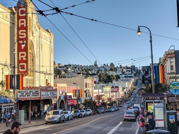
- Four different hilltop viewpoints that show how SF’s neighborhoods sit on and around steep ridgelines
- Secret-staircase and hidden-slide style details, plus gardens and a podium with a missing statue you’ll hear about
- Eureka Valley’s shifting identity, from 1850s outskirts to later Irish roots and big 1960s to 1970s changes
- Tank Hill’s city views as a standout moment where the city suddenly feels much bigger
- A snack break option at Hot Cookie (pay as you go) to keep your energy up
Hidden staircases and viewpoints worth the climb


Why Eureka Valley is the best setup for a four-peak hike
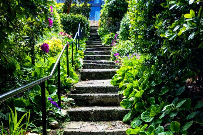
Most SF visitors start their sightseeing on flat ground and then scramble uphill when they realize the city is built on hills. This tour flips that. You base your walking in Eureka Valley, a neighborhood that has always been shaped by geography first and then by people.
Eureka Valley has carried multiple lives over time. It was once outside the core of the city, with the kind of outskirts feeling where Market Street ended and cows grazed. Later came the 1890s Irish community, including churches that helped anchor everyday life. In the 1960s, some streets got abandoned, and then the 1970s brought a return to life through the gay community. If you like history, you’ll appreciate how the guide connects what you see now with what once was there.
And if you’re more of a “show me the views” person, you’ll also like it. The hills here are not just scenery. They are why people lived where they did, why certain streets were cut or changed, and why rooftops and staircases matter. This route gives you a good reason to walk instead of just stand.
Finally, the small-group size matters. With a max of 8 travelers, the walk feels more like moving with a local friend than being swept along with a crowd.
Price and timing: $65 for a half-day of real SF contrasts
At $65 for about 3 to 4 hours, you’re paying for guided access to viewpoint planning and on-the-ground context. In plain terms, you could technically walk around these neighborhoods on your own, but the tour saves you the “what am I looking at” struggle.
All fees and taxes are included, so you’re not hit with surprises later. And the tour is built around short, focused segments rather than one long haul. That makes the time feel efficient: you’re not spending the whole half-day just marching from one random corner to another.
Your total effort is still real. You’re climbing and descending through multiple hill zones. But the payoff is that each stop is tied to a specific viewpoint or feature. Even if you’re just okay at hiking, you’ll get to enjoy the best vantage moments without the stress of finding them.
One practical note: the tour depends on good weather. If it’s rough out, you may be offered a different date or a full refund. So, when you book, try to keep at least a little flexibility in your schedule.
From Castro St to hilltop outlooks: what you get at the first peak zone
You start at Castro St and Market St, and that location is a smart beginning. It’s one of those intersections where SF’s layers show up fast, even before you climb. From there, you’ll move through the Castro edge of Eureka Valley while the guide frames the surrounding hills as part of the same story.
The first stop is built around the idea of four surrounding hills of Eureka Valley, so you’re not just getting one view. You’re getting the layout in your head. That helps the rest of the hike make sense, because later lookouts become easier to interpret. You’ll understand why Corona Heights and other ridges matter, and why streets feel cut or stretched depending on where you’re standing.
This part also sets expectations for the kind of walking you’ll do. You’re transitioning from street-level rhythm into the hill logic of SF: slopes, stairs, and sudden pockets of quiet. If you like urban details, you’ll probably notice small things more than usual because the guide keeps telling you what to watch for.
If you’re traveling with someone who only tolerates a little hiking, this is where you can test the comfort level. Once you see how quickly you’re moving uphill, you can decide if you’ll need to slow down or take extra breaks. The good news is that the time blocks are short.
Tank Hill: the views stop being postcard and start being useful
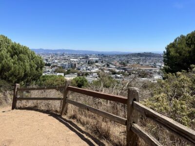
Tank Hill is the place where the city outlook gets serious. The route pauses long enough for you to actually look, not just glance and move on. You’ll likely feel the scale immediately, because Tank Hill’s vantage works as a real orientation tool. It helps you see where major areas sit relative to each other, and it makes the rest of the neighborhoods you’ve walked through feel connected.
The best way to enjoy this stop is to pick one direction and follow it. Don’t try to stare at everything at once. Ask yourself what you recognize, then let the view fill in what you don’t. If the guide points out key landmarks or tells you how the hill shapes movement and visibility, treat those as your “map anchors” for the rest of the walk.
This is also where photos make sense. You’ll be high enough to get a clean shot, but not so far removed that you lose the feeling of the neighborhood under you. It’s one of those moments where the city feels like it has depth, not just height.
A small caution: windy days can be a factor on hilltops. Even with good weather, keep a light layer handy so you can stay comfortable while you look around.

Corona Heights: cut-out streets, hidden features, and the Randall Museum finish
As you head toward Corona Heights, the tour shifts from big viewpoints to neighborhood structure. Corona Heights stretches between Buena Vista Park and the Eureka Valley area, and this part of SF was literally carved into the hills. That’s why the streets and blocks can feel different from what you expect. You’re watching the city’s design respond to terrain.
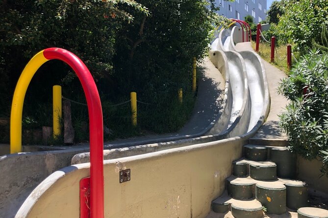
This is also where the “secret SF” style details start paying off. You may see references to hidden concrete slides, secluded gardens, and a podium with a missing statue. The names of these features matter less than the idea behind them: SF is full of design experiments that most visitors walk past without noticing. When a guide points out why a feature exists and how it was used, you start to recognize the same pattern elsewhere in town.
You’ll also get a sense of how streets that were abandoned in the 1960s later came back to life in the 1970s. That doesn’t mean you’ll see a time machine on the sidewalk. It means you’ll understand why certain areas feel open, why some buildings and streets feel like they have “returned,” and why people who live here care so much about the neighborhood story.
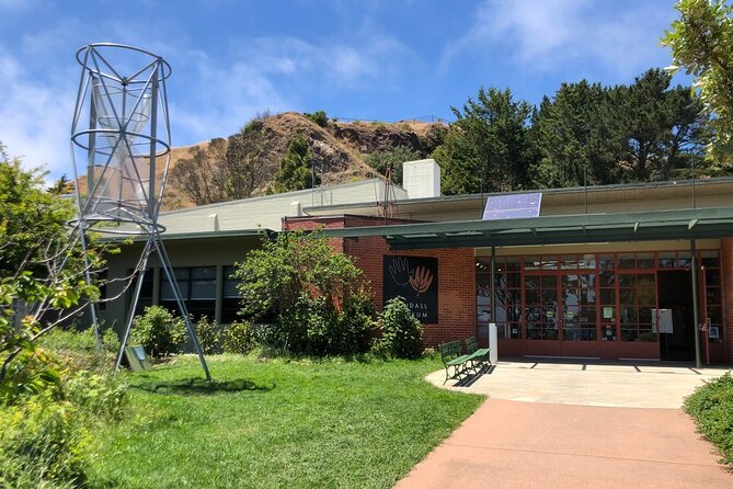
The tour concludes around the top of Corona Heights, with the Randall Museum nearby. Finishing up at the upper edge of the neighborhood gives you a sense of “complete loop” rather than ending in the middle of nowhere. It also helps because you’re ending on a grounded landmark area, which can be easier to navigate afterward.
The Hot Cookie stop and how to plan your snack situation
The tour includes a snack stop at the famous Hot Cookie, but snacks are not included in the price. That means you’re in charge of your own food budget during the break, which is usually what you want on a walking tour. You can grab something quick if you need it, or keep it simple if you ate before you started.
Because this is a hills walk, I recommend deciding ahead of time what you’ll do for water and small energy. The route is only half-day long, but the combination of stairs and steep streets can sneak up on you. If you know you get hungry, consider bringing a small snack even if you plan to buy something at the cookie stop.
Also, bring your own flexibility. If the weather is borderline, you might not want to linger too long. A snack break is helpful for morale, but the hilltops are still the main event.
What to wear, how to pace yourself, and how to get the most out of the guide
This is a walking tour with moderate physical fitness requirements. That doesn’t just mean speed. It means footing. You’ll be on sloped streets and you may be dealing with steps and uneven surfaces in neighborhood stairways. Hiking shoes are specifically recommended, and I agree. Even if you consider yourself “fine” at walking, the hill mix is different from flat city strolling.
Pacing matters too. A good strategy is to set a personal rule for rest stops. For example, you can take short breaks when you feel yourself rushing, not only when you’re tired. That keeps the hike enjoyable and makes the viewpoint times feel relaxed instead of rushed.
Now for the guide. The big theme across positive experiences is that the guide is enthusiastic and tells stories that make the city make sense. Ryan specifically comes up as a standout leader, with a friendly style and lots of area detail. That kind of guide makes it easier to connect the physical walk to the cultural timeline. You’re not just collecting pretty views, you’re learning why those views exist.
Who should book, and who might prefer something else
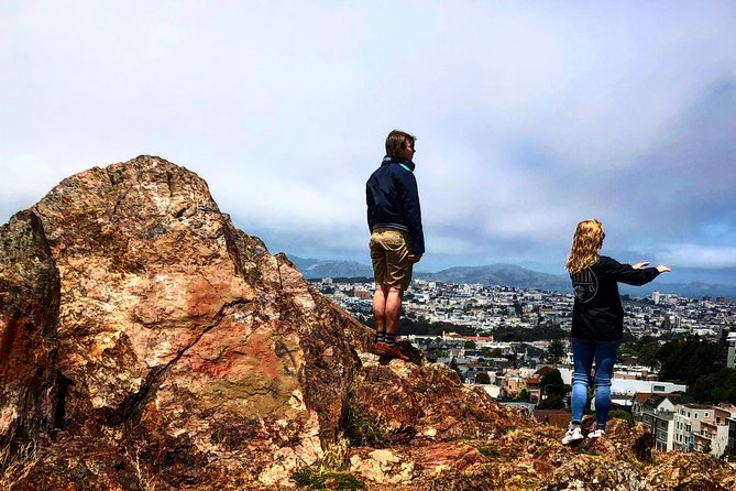
This tour is a great fit if you want a guided way to understand SF’s neighborhood layers. You don’t need to be a history buff to enjoy it, but if you like knowing why places feel the way they do, Eureka Valley’s timeline will click.
You’ll also enjoy it if you like views but hate the idea of spending the whole day hiking with no plan. The tour gives you four hilltop angles, not random wandering.
It may not be ideal if you have limited tolerance for stairs or steep inclines. Even at a moderate level, hill hikes ask more of your legs than you expect. If you’re unsure, prioritize footwear and consider going on a day with stable weather.
Finally, this tour has a maximum of 8 travelers. That means it can feel personal, but it can also mean the experience depends heavily on the leader and the conditions.
Should you book the San Francisco Four Peaks Tour?
I’d book it if your goal is to see SF from multiple angles while learning how a single neighborhood evolved. For $65, you’re getting a guided structure that turns steep streets, stairways, and overlooked features into a coherent story, plus a couple of high points where the city scale suddenly hits.
Book it especially if you care about authentic local context. The Eureka Valley setting lets you connect 1850s outskirts, 1890s Irish community landmarks, and later street shifts into one walking route, then finish near the Randall Museum at the top of Corona Heights.
I’d think twice if hills and steps are hard for you, because the walking is the main activity. And if you’re on a tight schedule, it’s smart to have a backup day in mind. Weather can affect the route, and like any small operator-led experience, last-minute changes are always possible, even if cancellation rules generally protect you when you cancel far enough ahead.
If that all sounds manageable, this is a solid, high-value way to experience San Francisco’s neighborhoods the way locals do, on foot, with viewpoints earned step by step.
FAQ
How long is the San Francisco Four Peaks Tour?
It runs about 3 to 4 hours.
Where does the tour start and end?
The tour starts at Castro St and Market St, and it ends back at the same meeting point.
How much does the tour cost, and what’s included?
The price is $65, and it includes all fees and taxes.
Is admission included for the sights?
Admission is listed as ticket free for the stops shown.
Are snacks included?
No. Snacks are not included, but there is a snack stop at Hot Cookie where you can purchase food.
How many people are in each group?
The tour has a maximum of 8 travelers.
What fitness level do I need?
You should have a moderate physical fitness level.
Does the tour operate in bad weather?
It requires good weather. If it is canceled due to poor weather, you will be offered a different date or a full refund.
What is the cancellation window?
You can cancel up to 24 hours in advance for a full refund. Within 24 hours, the amount paid is not refunded.
More Tours in San Francisco
- Big Bus SF: Hop-on Hop-off Tour with 17 Stops and Sunset Option★ 4.0 · 4,539 reviews
- Napa and Sonoma Wine Country Full-Day Tour from San Francisco★ 4.5 · 4,455 reviews
- San Francisco: Hop-On Hop-Off Sightseeing Tour with 17 Stops★ 4.5 · 3,600 reviews
- Yosemite Highlights & Giant Sequoias Day Tour from San Francisco★ 4.5 · 3,455 reviews
- San Francisco Love Tour★ 5.0 · 2,830 reviews
- San Francisco: Alcatraz Island & 48-Hour Hop-On Hop-Off Tour★ 4.6 · 2,245 reviews
More Tour Reviews in San Francisco
- Muir Woods and Sausalito (Return by Bus or Ferry)★ 4.5 · 5,098 reviews
- Big Bus SF: Hop-on Hop-off Tour with 17 Stops and Sunset Option★ 4.0 · 4,539 reviews
- Napa and Sonoma Wine Country Full-Day Tour from San Francisco★ 4.5 · 4,455 reviews
- Small Group Yosemite and Giant Sequoias Day Trip from San Francisco★ 5.0 · 3,671 reviews
- San Francisco: Golden Gate Bay Cruise★ 4.7 · 3,644 reviews
- San Francisco: Hop-On Hop-Off Sightseeing Tour with 17 Stops★ 4.5 · 3,600 reviews
Stairways Worth the San Francisco Climb
- Hidden Stairways of San Francisco★ 5.0 · 244 reviews
- San Francisco Urban Hike: Castro and Twin Peaks★ 5.0 · 71 reviews
- Hidden Stairways of San Francisco★ 5.0 · 24 reviews
- San Francisco Presidio Walking Tour★ 5.0 · 19 reviews
- San Francisco Urban Hike: Coit Tower, Lombard Street and North Beach★ 5.0 · 11 reviews
- Iconic San Francisco Urban Hiking Tour★ 5.0 · 7 reviews
Fresh arrivals for a San Francisco itinerary
- San Francisco: Tour De San Francisco (Electric Bike Tour)
★ 4.7 · 3 reviews - Private Exploration of the Birds of San Francisco
★ 5.0 · 4 reviews - Zion, Bryce, Antelope, Grand Canyon, Las Vegas 6-Day Tour from SF
★ 5.0 · 3 reviews - Private Tour of Yosemite a Two Day Exploration
★ 5.0 · 4 reviews - The Presidio: Main Post to the Golden Gate Bridge
★ 5.0 · 3 reviews - Alcatraz Island Tour with San Francisco Bay Tour
★ 3.5 · 4 reviews
More ways into Urban Hikes, Stairways & City Walks
 ★ 5.0Hidden Stairways of San FranciscoFrom $37244 reviews
 ★ 5.0San Francisco Urban Hike: Castro and Twin Peaks71 reviews
★ 5.0Hidden Stairways of San FranciscoFrom $3724 reviews
★ 5.0San Francisco Urban Hike: Castro and Twin Peaks71 reviews
★ 5.0Hidden Stairways of San FranciscoFrom $3724 reviews
 ★ 5.0San Francisco Presidio Walking TourFrom $4919 reviews
 ★ 5.0San Francisco Urban Hike: Coit Tower, Lombard Street and North BeachFrom $5411 reviews
 ★ 5.0Iconic San Francisco Urban Hiking TourFrom $497 reviews
 ★ 4.5Lombard Leap: Lombard Street, Coit Tower and Chinatown TourFrom $296 reviews
 ★ 4.2Neighborhood Walking Tour – 6 Route OptionsFrom $655 reviews
Try another angle on the same itinerary